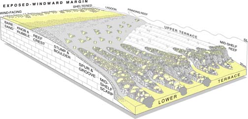
| Reef
system geology involves an examination of the morphology, internal
structure and composition of coral reefs in an attempt to determine
when they started to grow, how they developed and what processes
controlled that development. We concentrate our efforts on both
modern reefs which have developed over the last few thousand
years, and also on their fossil counterparts which developed
during previous interglaciations. |
La
geología de sistemas arrecifales examina la morfología,
estructura interna y composición de los arrecifes e intenta
determinar cuando empezaron a crecer, cómo se desarrollaron
y qué procesos controlaron ese desarrollo. Concentramos
nuestros esfuerzos tanto en arrecifes modernos, que se han desarrollado
en los últimos miles de años, como en sus equivalentes
fósiles que se desarrollaron durante periodos interglaciares
anteriores. |
On
modern reefs, our basic source of information comes from
cores that we extract using a rotary coring drill. We choose
a core site where we can drill on dead-coral rock without
damageing the surrounding live corals. Once the core is
extracted, we cover the hole and leave conditions exactly
as we found them. We repeat this proceedure in many places
along the reef in order to reconstruct a detailed picture
of reef structure and development. To supplement these core
data, we plant experimental substrates on various parts
of the reef to examine the rates and sequence of reef processes.
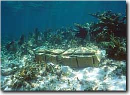
Experimental
Substrates on the reef crest
In
the fossil reefs, we use both coring and information from
natural rocky exposures. Using sedimentological and paleoecological
data from these sources, we try and piece together the structure
of the fossil reef in a way that is a bit like doing giant,
three dimensional jigsaw puzzle, but without having the
original picture to help.
Once
reconstructed, we then need to determine the exact timing
of reef development. To date the stages of reef growth we
utilise two radioisotopic techniques: U-Series and Radiocarbon
dating. Both rely on the decay of long-lived radiogenic
isotopes that are naturally found in the coral skeleton
(Uranium 234 and Carbon 14). The quantity of these elements
and their decay products in the fossil corals is proportional
to their age but it is usually so small that extremely sensitive
machines called Mass Spectrometers are needed to detect
them.
When
the analyses are complete and we know when, how and why
a particular reef developed, we can apply this knowledge
to solve scientific and societal problems. Knowledge of
reef development is particularly value for asessing past
climate variability. This is because reefs record the exact
position of sea level during their development and so alow
us to identify how sea level has changed through time. Given
that sea level directly reflects the ice-to-water ratio
on Earth, knowing its variation through time enables the
amount of ice locked up in ice caps and glaciers to be quantified
and therefore delineates major oscillations in climate that
were responsible for generating the Ice Ages.
For
example, during the last Interglaciation 125,000 years ago,
fossil reefs along the coast of Quintana Roo and around
the world grew at elevations 6 m higher than today. This
implies that global climate was warmer because there was
less ice locked up on land in places like Greenland and
the Antarctic. The big question is how did sea-level rise
to this level? Did it involve rapid changes due to the collapse
of these ice-sheets, or was it more gradual with ice-sheets
slowly melting. Studying how fossil reefs developed during
the last interglaciation can help answer this question.
And knowing the answer is, of course, very important for
prediciting how sea level will rise in the future in response
to global warming caused by the burning of fossil fuels.
If an ice sheet collapses due to this warming Cozumel could
very quickly start to look like Alacranes.

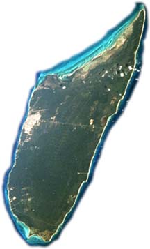
Alacranes,
a Holocene Atoll | Atolón
moderno
|
Nuestra
fuente básica de información proviene de exposiciones
en la roca y de núcleos que extraemos usando un taladro
hidráulico. En un arrecife moderno, escogemos un sitio
dónde poder taladrar el substrato sin dañar
los corales vivos de alrededor. Una vez que extraemos el núcleo,
rellenamos el agujero y dejamos las condiciones justo como
las encontramos. Repetimos este proceso en varios sitios a
todo lo largo del arrecife para poder reconstruir una imagen
detallada del desarrollo arrecifal.
En
los arrecifes fósiles usamos núcleos e información
de exposiciones naturales y hechas por el hombre (hoyos o
excavac-iones). Usando estos datos tratamos de reconstruir
la estructura del arrecife fósil de la misma manera
que armaríamos un rompecabezas tridimensional. ¡Con
la diferencia de que no tenemos una imagen para guiarnos!
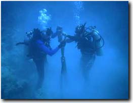
Drilling
in the reef-front zone
Una
vez reconstruido, necesitamos determinar el tiempo exacto
del desarrollo del arrecife. Para fechar las etapas de crecimiento
del arrecife usamos dos técnicas: U-Th (Uranio-Torio)
y Radiocarbono. Ambos se basan en el decaimiento de elementos
radioactivos de vida larga que se encuentran, de forma natural,
en el esqueleto de los corales. La cantidad de estos elementos
es, generalmente, tan pequeña que son necesarias instrumentos
extremadamente sensibles, llamados Espectrómetros de
Masas, para detectarlos.
Con todos estos datos podemos mostrar cuando, dónde
y porqué un arrecife en particular se desarrolló.
Además de ser una aportación al conocimiento
científico, esta información tiene también
un valor práctico. Por ejemplo, los arrecifes marcan
la posición del nivel del mar y por tanto nos permiten
determinar cual era la proporción hielo/agua en la
Tierra del pasado. Durante el último periodo interglaciar,
125 000 años atrás, los arrecifes de la costa
de Quintana Roo crecían hasta 6 metros más elevados
que los de ahora. Esto nos indica que el nivel del mar era
mayor y que las capas de hielo de Groenlandia o la Antártica
se habían colapsado.
¿Por
qué es importante saber esto? Bueno, se predice que
el nivel del mar va a aumentar varios metros en el siguiente
siglo e inundar por tanto áreas costeras importantes
para nuestra economía. La pregunta es, ¿qué
tan pronto Cozumel se verá como Alacranes?
Cozumel,
a Pleistocene Atoll | Atolón
fósil
|